‘Storm Shield’ Over Pacific Leaves Northern California Waiting for Precipitation
December is typically one of Northern California’s wettest months, but early forecasts show the region staying unusually dry through at least mid-month.
A strong high-pressure system parked in the northeastern Pacific is acting like a “storm shield,” diverting Pacific storms north into Canada before they slide south over land as “inside sliders.”
These inland systems don’t carry much moisture, meaning most of Northern California will miss out on meaningful rain or snow. The Tahoe region could see light flurries around December 3, but areas west of the Sierra are expected to remain dry.
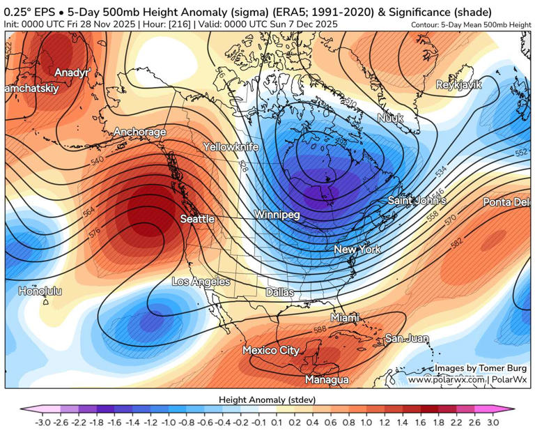
A potential cutoff low between December 4–6 offers the state its best chance at early-December precipitation, mainly for Southern California. For the northern half of the state, the odds remain slim, with long-range models showing a high probability of minimal or no rainfall through December 12.
Temperature inversions will also shape early December. Fog-prone valleys, including much of the Central Valley, may stay locked under cold, gray conditions while higher elevations experience warmer-than-normal days. That warm air could continue to erode the Sierra snowpack, already struggling after a weak start to the season.
The dry pattern is tied to a disrupted stratosphere and hints of La Niña, both contributing to a wavy, stalled jet stream. These winter blocking patterns are becoming more common and may be connected to record-low Arctic sea ice.
A shift could arrive around December 10–14 if the high pressure finally breaks down or moves east, opening the door for colder coastal storms. But for now, Northern California looks headed for a dry, and potentially drier-than-normal, start to December.