Bay Area Could See Its Highest Tides in 30 Years This Weekend
Parts of the Bay Area could see coastal flooding this weekend as a rare combination of record-high tides and stormy weather pushes water levels well above normal.
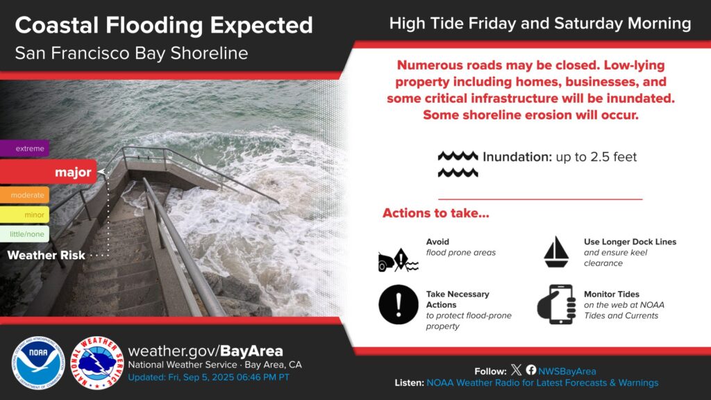
The National Weather Service has issued a coastal flood warning for shoreline areas around San Francisco Bay through Saturday afternoon. Forecasters say tides could rise as much as 2.5 feet above normal, potentially setting the highest tide seen in nearly three decades.
These unusually high water levels are being driven by king tides, which occur when gravitational forces from the sun and moon align during a full moon. That effect is being amplified by storm surge and incoming weather systems, pushing water farther inland than typical high tides.
Compounding the issue, another atmospheric river is expected to arrive Friday night, bringing additional rain and strong winds to an already saturated region. Rain totals through Sunday could reach around 1.5 inches in San Francisco, 1.7 inches in Santa Rosa, 1.2 inches in Oakland, and 1 inch in San Jose. Wind gusts may approach 50 mph in parts of the Bay Area, prompting a wind advisory.
The coastal flood warning remains in effect until 2 p.m. Saturday, followed by a coastal flood advisory lasting through 2 p.m. Sunday. Low-lying roads, waterfront neighborhoods, and areas near the shoreline may experience flooding during peak high tides.
Officials urge residents and visitors to avoid flooded areas, never drive around barricades, and use NOAA flood maps to check whether their location is vulnerable.