‘Downed Trees and Power Outages are Likely’: Extreme Winds Expected in NorCal Today
The National Weather Service (NWS) has issued a High Wind Warning for the Sierra region above 4,000 feet, with a forecast predicting strong and potentially damaging winds from this evening through Friday. This advisory extends to include gusty winds across other areas, signaling a notable shift in weather patterns that also heralds a warming and drying trend expected to last into next week.
“Gusty winds will continue into Friday,” wrote the NWS on Twitter. “Difficult driving conditions are likely. Downed trees and power outages are likely in the mountains. Be sure to drive with caution in/around high profile vehicles & watch for any downed trees.”
Meteorologists attribute the upcoming north to east wind event to a cool upper low descending from western Canada into the Great Basin, in combination with a building eastern Pacific ridge into the Pacific Northwest. This setup is primed to funnel strong and gusty winds down the Sacramento Valley, across the Delta, and along the Sierra slopes, particularly affecting areas along Interstate 80 from Blue Canyon to Donner Pass and extending towards Yosemite.
Gusty winds will continue into Friday. Difficult driving conditions are likely. Downed trees and power outages are likely in the mountains. Be sure to drive with caution in/around high profile vehicles & watch for any downed trees. #CAwx pic.twitter.com/Zo0pIyoGJ8
— NWS Sacramento (@NWSSacramento) March 14, 2024
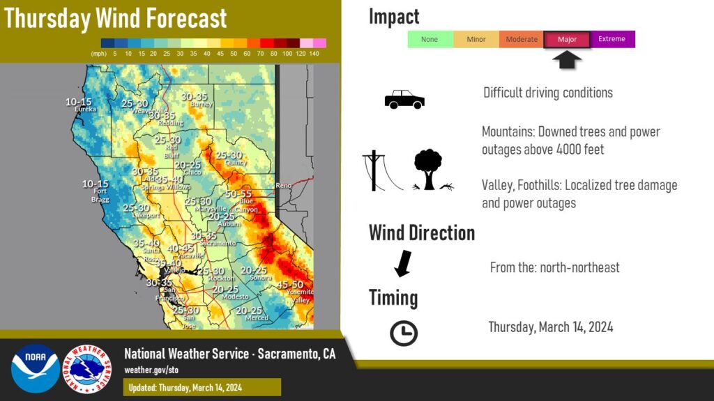
With the Extreme Forecast Index (EFI) signaling unusual wind speeds and gusts over the Sierra, regions above 4,000 feet are bracing for northeast winds reaching speeds of 40 to 55 mph and gusts that could surge up to 80 mph. These powerful winds pose risks of downing trees and power lines, leading to power outages and challenging travel conditions, especially for high-profile vehicles.
In addition to the High Wind Warning for the Sierra, a Wind Advisory is in effect for the Northern, Central, and Southern Sacramento Valley, parts of the northern Coastal Range, the Carquinez Strait and Delta, and the Northern San Joaquin Valley. Residents can expect north winds of 25 to 35 mph, with gusts up to 45 mph, capable of causing tree limbs to fall and resulting in sporadic power outages.
As the strong winds are expected to taper off late Friday with the weakening and eastward shift of the low over Arizona, a ridge of high pressure will build over Northern California. This shift will usher in a weekend of dry weather with valley highs in the 70s, marking a period of above-normal temperatures, though record highs are not anticipated at this time. Residents and travelers are advised to stay updated on the latest weather forecasts and prepare for the changing conditions.