Pineapple Express Storm Could Bring 4 Feet of Snow, Flooding to Northern California this Week
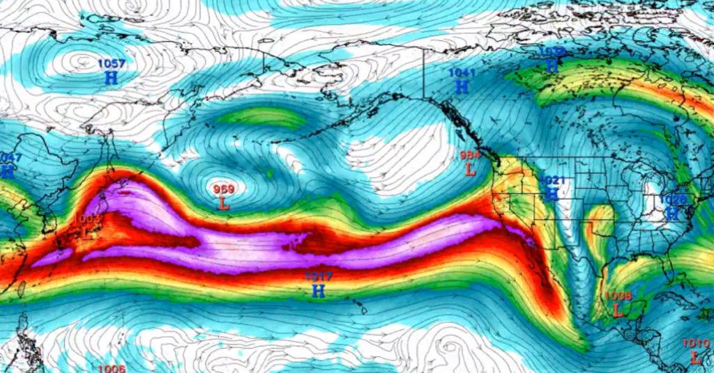
Northern California is gearing up for a deluge as the Pineapple Express, an atmospheric river originating near Hawaii, takes aim at the region this week from Tuesday through Friday. Coastal areas may experience a soaking with up to 8 inches of rain in the forecast, and the mountains could see up to 4 feet of snow.
Pineapple Express storms are renowned for their ability to channel a colossal amount of moisture from the Pacific Ocean to the West Coast. This atmospheric river can transport as much as 27 times the water volume of the mighty Mississippi River, equivalent to 10 to 15 inches of rainfall.
A Pacific jet extension will roar across the Pacific to begin February, bringing the potential for a significant atmospheric river event for California and the West Coast.
— Colin McCarthy (@US_Stormwatch) January 23, 2024
A classic El Niño pattern. Stay tuned. pic.twitter.com/zmWsur9bI4
“That jet stream is going to be oriented right from west to east, and that means very warm air and a lot of Pacific juice coming right across parts of California,” explained meteorologist Bob Van Dillen. “Look at the track of this, too. We see that fetch coming all the way from Hawaii, and that’s going to stretch through the Pacific and into the lower parts of California.”
In the Sierra Nevada, higher elevations could witness a considerable snowfall of 1 to 3 feet this week, including up to 4 feet in Lassen Volcanic National Park. The snowfall will certainly force chain controls over mountain passes and possibly full road closures through the weekend.
Unfortunately, the warmer Pineapple Express storm had rain falling as high as 6,000 feet earlier in the week. But as the temperatures decrease, snow levels are expected to drop to around 3,000 feet by Friday.
Here's a look at the snow forecast for the mid-week storm we're expecting. Snow levels will start high on Wednesday and slowly lower over the course of the storm. Heaviest snowfall will occur Wednesday PM-Thursday. Keep an eye on road conditions at https://t.co/6jnhwJwK5a! #CAwx pic.twitter.com/vW0dQjbIGd
— NWS Sacramento (@NWSSacramento) January 28, 2024
The region’s already saturated ground raises concerns about rising river levels and potential flooding, as well as an increased risk of landslides. The concerns are specifically related to the North Coast communities near Humboldt County, which recently experienced river overflows that stranded people in their communities.
Heavy Rain is expected to bring flooding on Wednesday and into Thursday. There is still uncertainty on the timing and strength of the rainfall, but confidence is growing that there will be flooding. Stay tuned to https://t.co/lQYrrn6L9M. pic.twitter.com/N2gpQcuzj7
— NWS Eureka (@NWSEureka) January 28, 2024
“The good news here is that it’s going to be strong; it’s going to be heavy at times, but it’s going to be transient; it’s going to be moving pretty quickly,” said Van Dillen. “So it’s not going to be at the same spot for a long period.”
Nevertheless, significant rainfall is anticipated across Northern California starting on Wednesday, with some of the region expected to receive 2 to 4 inches of rain.
Rain is returning this week, starting Tuesday evening. Heaviest precip will occur Wednesday into Thursday, with lighter showers before and after that time period. Drive carefully and allow extra time for your commute! Roads will be slick, and roadway ponding will occur. #CAwx pic.twitter.com/rmGfLfZTQV
— NWS Sacramento (@NWSSacramento) January 28, 2024
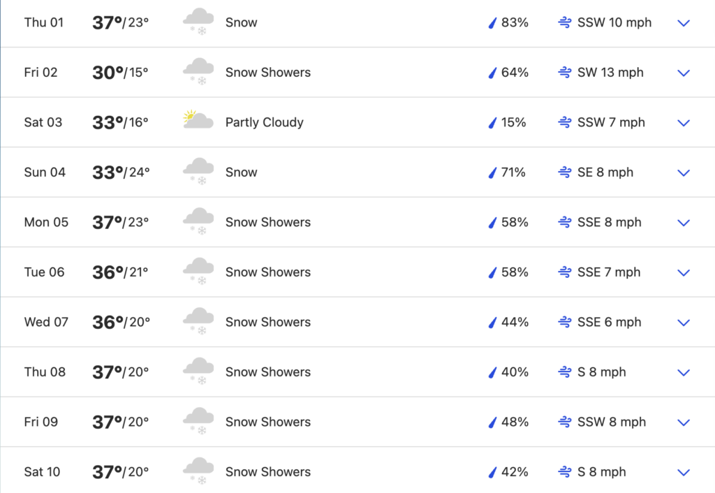
Early forecasts show another storm moving into the region next week as well, with precipitation expected to last from Sunday, February 4, through Saturday, February 10. Could we be on the verge of a FebruBURIED? Here’s the weather forecast for South Lake Tahoe:
Buckle up, Northern California! We are in the midst of winter, and things are about to get crazy. Remember to please be safe in high-elevation mountains and around any potential flooding areas.